Platform on window, door, frame technology, hardware, roof and facade technology, security
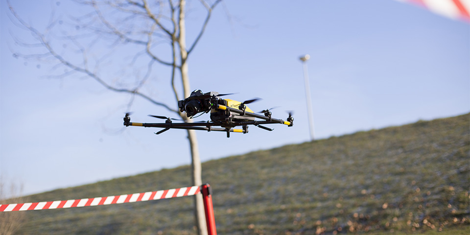
This spring, for the first time, legal drone flights took place in urban areas. This happened within the innovation project FaSA. This project runs over a three-year period in which a "Façade Service Application" is being developed. Initiators are VMRG, OCTO and Aeroscan working together with 39 public and private parties.
Stingo Huurdeman of the VMRG: "FaSA is a platform that innovates the physical real estate market through the use of digital means such as sensors, drones and artificial intelligence. This allows continuous insight into the technical and aesthetic performance of facades of residential and commercial buildings in an objective manner. Innovation in facade construction is high on the VMRG's agenda. Hence, the VMRG is happy to contribute its knowledge about technology and maintenance in facade construction to this project."
As part of the FaSA project, the first pilots consisting of several drone flights in residential areas were recently conducted. "And that is quite special," explains Mark Nicolai of Aeroscan, "because these were the very first pilot flights in urban areas. In fact, we were the first in the Netherlands to receive permission for this from the Environmental and Transport Inspectorate and the Ministry of Defense. Such a flight starts with thorough preparation, not only in terms of procedures and technology, but especially when it comes to privacy and communication. These were flights in a residential area, so beforehand the residents, in consultation with the housing associations with whom we work in the FaSA project, are informed very extensively."
With drone flights, privacy is an issue that is taken very seriously. Nicolai indicates: "Prior to the pilot flights, tenants will receive a letter from the housing corporation explaining the inspections. This emphasizes that we focus on the technical aspects of the exterior of a house and emphatically not on persons or personal property. Should there nevertheless be persons or, for example, license plates on the images, they are "blurred" and only the adjusted images are shared with the client. The raw files are deleted." In addition, drawings are made prior to the pilot flights to outline the route the drone will fly during the pilot. In addition, information meetings are organized for local residents to view the recorded images. The initial response to this has been very positive. It appears to be very fun and interesting to see one's own neighborhood through drone footage.
A large housing complex is expensive to inspect. A drone does the job faster, more accurately and cheaper. "Here we work with drones that are currently the best in terms of safety and technology," Nicolai says. The drones fly at an appropriate distance and from the air, the camera on the device takes pictures of the roof, facade and window frames. The camera takes pictures in a very high resolution and maps deviations at millimeter level in razor-sharp detail. To get an overall picture of a building, the images obtained will eventually have to be linked to ground photography as well. "In my ideal picture, in a few years' time we will signal a leak even before it is a leak," says Dirk Huibers of Octo. "Then a tenant won't have to report it, it will immediately ring a bell to a contractor or façade builder, and they can repair a near leak before the damage gets worse." Huurdeman adds: "This also means for facade maintenance that work will be done in a completely different way in the future. A building will be continuously monitored. For this we will also develop new sensors in this project. This will allow you to predict maintenance very accurately. No maintenance when it's already too late, but preventive maintenance." "But," Huibers continues, "we are not that far yet, we will first have to translate the images into information and run analyses on them."
It will also be necessary to examine what it will take to scale up these drone inspections to the neighborhood level and how to do so as well and efficiently as possible. "We are consulting with legislative bodies about what is needed to apply this widely," Huibers says. "Of all the pilot flights, we have properly recorded what happened and we evaluate that. In order to then be able to indicate improvements that we can take back to the next phase. After the first pilots, we are mainly very positive about the results. The flights have been safe, the drones take excellent pictures and they held up well in wind force five. We are making very big steps technically, bigger than we had dared to think."
This project comes in part through support from Opportunities for West II, ERDF grant.
Louwers Mediagroep
Schatbeurderlaan 6
6002 ED Weert
 © 1987 - 2025 Louwers Media Group.